
This article will guide you on how to reach Kedarnath from Gaurikund. If you want to visit Kedarnath Temple then Gaurikund is the last destination that is accessible from major destinations of Uttarakhand.
Gaurikund is a Hindu pilgrimage site and base camp for trek to Kedarnath Mandir. It is situated at an altitude of 6502 feet above mean sea level in the Garhwal Himalayas in the Rudraprayag district of Uttarakhand.
This new route to Kedarnath Temple is constructed by NIM team members. Various teams are working to maintain the best suitable path to Kedarnath.
The new route via Rambara and Linchauli is a major trek route to reach Kedarnath. Rambara has completely washed away in the 2013 flash floods. Now the only newly constructed bridge is to the landmark Rambara.
This Kedarnath trek is maintained by NIM – Nehru Institute of Mountaineering.
Gaurikund To Kedarnath Trek Distance
The roads towards Kedarnath Temple only stretch till Gauri Kund. After that, you have to take a 16 km trek towards the sacred shrine Kedarnath Mandir.
Kedarnath Trek is beautifully and naturally designed on the bank of the Mandakini River. There are some short shelter points in between the Kedarnath trek.
Total Length = 16 kilometers
Gaurikund to Kedarnath Distance by Walk
The distance between Gaurikund and Kedarnath is approximately 16 kilometers (9.9 miles) via the traditional trekking route. The trek takes around 6 to 8 hours, depending on your physical fitness level and the weather conditions.
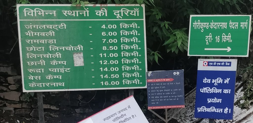
4 km = Gaurikund To Jangle Chatti /Bhairon Chatti
3 km = Jangle/Bhairon Chatti To Bheembali
4 km = Bheembali To Linchauli
4 km = Linchauli To K. Base Camp
1 km = K. Base Camp To Kedarnath Temple
Up-Down Timings
- Last timing for Upcoming Visitors – 5 Pm (Evening)
- Last timing for Downcoming Visitors – 6:30 PM (Evening)
Don’t forget to check out this Best-selling TREKKING Bag on Amazon
7358 Ratings with ★★★★ (4.4+ Customer Review)

To complete the Kedarnath trek, you have three options there.
- by Walking
- by Ponies
- by Palkies
If you have a good budget, then you can also hire Helicopter Services during the peak season of the Char Dham Yatra. The hard journey to the great abode of Shiva is well remunerated with the spiritual atmosphere which is created by the peaceful sober and splendid beauty of the region.
The magnificent Kedarnath peak (6,940 meters) stands behind the temple with other peaks, forming a perfect setting for the holy land of the supreme deity (Mahadev).
The conical-shaped Shiva lingam (hump) in the Kedarnath temple is a unique feature and one of the 12 jyotirlingas of Lord Shiva.
Other Than this Palkis and Ponies Facilities are also available.
Explore Kedarnath
- Kedarnath Jyotirlinga Stroy
- Kedarnath Shivling Story
- Kedarnath Flood Story
- Read Kedarnath Blog
- Kedarnath itinerary Plan
Gaurikund To Kedarnath Trek Route Map
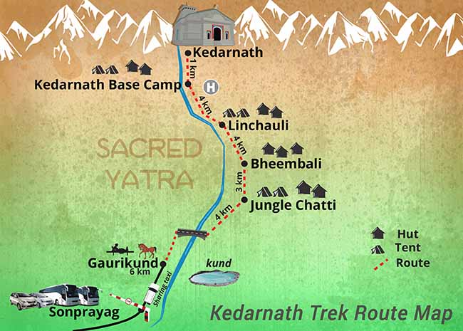
Kedarnath Trek (Paidal Marg) is divided into many resting sheds. En route Kedarnath from to Gaurikund, there are several facilities provided by the administration.
Medical and First aid facilities are available at Bhimbali, Lincholi, and Kedarnath. There is also a 10 bedded hospital with ECG with modern facilities at Kedarnath. Apart from Medical, Tea/Coffee shops, there are resting sheds also available on the route.
Gaurikund ➜ Jungle/Bhairon Chatti ➜ Bheembali ➜ Linchauli ➜ Kedarnath Base Camp ➜ Kedarnath Temple
New Route Checkpoints between Gaurikund to Kedarnath
There are mainly 10 Checkpoints in the route of the Kedarnath Trek. These checkpoints are shown below in the order they come during the 16km trekking.
- Gaurikund (गौरीकुंड)
- Jangal Chatti (जंगल चट्टी)
- Bheembali (भीमबली)
- Rambara (रामबाड़ा)
- Chhota Lincholi (छोटी लिंचोली)
- Lincholi (लिंचोली)
- Chhani Camp (छानी कैंप)
- Rudra Point (रूद्र पॉइंट)
- Base Camp (बेस कैंप)
- Kedarnath Temple (केदारनाथ मंदिर)
Don’t forget to check out this Best-selling TREKKING Bag on Amazon
7358 Ratings with ★★★★ (4.4+ Customer Review)
Palkis and Ponies Services in Kedarnath
Price Charges for both Palkis and Ponies depend upon the distance, nature of the trip (one way/round), uphill/downhill journey, same/next day return, and weight of the passenger.
Horses, ponies, and Palkies are available to climb up this steep path. Though the flash floods of 2013 desolated Kedarnath, work is being done to resuscitate it to its former glory. The trekking path to Kedarnath is a little different.
The Nehru Institute of Mountaineering has set up sheds at every few kilometers where the devotees can rest during this uphill trek. It is better to wake up early in the morning for the temple since it is closed between 3 PM to 5 PM.
While here, you may also trek 3 km ahead from the main temple to visit the beautiful lake, Chorabari Tal. Trekking 4 km ahead, you can see beautiful Himalayan peaks being reflected in the crystal clear waters of Vasuki Tal.
Travel Guide for Char Dhams:
- Badrinath Yatra 2023 Guide
- Gangotri Yatra 2023 Guide
- Yamunotri Yatra 2023 Guide
- Panch Kedar Yatra 2023 Guide
Kedarnath Distance from various Cities of India
Here we are sharing a detailed Route Map & Distance Guide on how to reach Kedarnath from major cities in India.
Click on Any Route below and you will redirect to a detailed Guide on that Route.
⦿ Delhi To Kedarnath (466 km)
⦿ Rishikesh To Kedarnath (227 km)
⦿ Haridwar To Kedarnath (252 km)
⦿ Dehradun To Kedarnath (266 km)
⦿ Mumbai To Kedarnath (1912 km)
⦿ Chandigarh To Kedarnath (524 km)
⦿ Jaipur To Kedarnath (758 km)
⦿ Lucknow To Kedarnath (730 km)
⦿ Ahmedabad To Kedarnath (1431 km)
⦿ Banglore To Kedarnath (2558 km)
⦿ Chennai To Kedarnath (2609 km)
⦿ Kolkata To Kedarnath (1699 km)
⦿ Pune To Kedarnath (1913 km)
⦿ Hyderabad To Kedarnath (1685 km)
FAQ about Gaurikund to Kedarnath
Frequently Asked Questions about Gaurikund to Kedarnath Trek.
Where is Gaurikund?
Gaurikund is a small town located in the Rudraprayag district of the Indian state of Uttarakhand. It is situated at an altitude of 1,982 meters (6,503 feet) above sea level and is considered to be the starting point of the trek to Kedarnath, one of the four sacred shrines of the Hindu religion.
Gaurikund is approximately 200 kilometers (124 miles) from the city of Rishikesh and can be reached by road from nearby towns and cities. It is also well connected by road to other parts of Uttarakhand and neighboring states.
How to reach Kedarnath from Gaurikund?
To reach Kedarnath from Gaurikund, you need to trek a distance of approximately 16 kilometers (9.9 miles) via the traditional trekking route. The trek takes around 6 to 8 hours, depending on your physical fitness level and the weather conditions.
You can also hire a mule or a pony for the trek. The new Swachh Bharat Kedarnath Trek Route is also available, which is said to be less steep and more comfortable to trek on.
Once you reach Kedarnath, you can visit the Kedarnath Temple, one of the most sacred shrines of the Hindu religion.
How much time does it take to reach Kedarnath from Gaurikund?
The trek from Gaurikund to Kedarnath takes approximately 6 to 8 hours, depending on your physical fitness level and the weather conditions.
The trek is approximately 16 kilometers (9.9 miles) via the traditional trekking route, and it involves ascending steep inclines and navigating narrow trails.
The time taken to complete the trek may vary depending on factors such as your pace, rest breaks, and the time of year.
How to reach Gaurikund from Delhi?
To reach Gaurikund from Delhi, you need to take a combination of road and rail transport. The nearest railway station to Gaurikund is Haridwar Junction, which is approximately 236 kilometers (147 miles) from Gaurikund.
From Haridwar, you can hire a taxi or take a bus to reach Gaurikund. Alternatively, you can take a direct bus from Delhi to Gaurikund, which is available during the pilgrimage season.
However, the journey time may vary depending on traffic and weather conditions.
How to reach Gaurikund from Rishikesh?
To reach Gaurikund from Rishikesh, you can take a bus or hire a taxi or a private car. Gaurikund is approximately 200 kilometers (124 miles) from Rishikesh, and the journey time may vary depending on traffic and weather conditions.
The most convenient way to reach Gaurikund from Rishikesh is to hire a taxi or a private car, which will take you directly to Gaurikund. Alternatively, you can take a bus from Rishikesh to Rudraprayag and then take another bus from Rudraprayag to Gaurikund.
The bus journey from Rishikesh to Gaurikund takes around 9 to 10 hours, while the taxi or private car journey takes around 6 to 7 hours.
How to reach Gaurikund from Haridwar?
To reach Gaurikund from Haridwar, you can take a bus or hire a taxi or a private car. The distance between Haridwar and Gaurikund is approximately 225 kilometers (140 miles), and the journey time may vary depending on traffic and weather conditions.
The most convenient way to reach Gaurikund from Haridwar is to hire a taxi or a private car, which will take you directly to Gaurikund. Alternatively, you can take a bus from Haridwar to Rudraprayag and then take another bus from Rudraprayag to Gaurikund.
The bus journey from Haridwar to Gaurikund takes around 9 to 10 hours, while the taxi or private car journey takes around 6 to 7 hours.
How to reach Gaurikund from Dehradun?
To reach Gaurikund from Dehradun, you can take a bus or hire a taxi or a private car. The distance between Dehradun and Gaurikund is approximately 246 kilometers (153 miles), and the journey time may vary depending on traffic and weather conditions.
The most convenient way to reach Gaurikund from Dehradun is to hire a taxi or a private car, which will take you directly to Gaurikund. Alternatively, you can take a bus from Dehradun to Rudraprayag and then take another bus from Rudraprayag to Gaurikund.
The bus journey from Dehradun to Gaurikund takes around 10 to 11 hours, while the taxi or private car journey takes around 7 to 8 hours.